THE COLOMBIAN AMAZON: POPULATED AND URBANIZED
This article is a reflection on how two visions have converged to inhabit the indigenous Colombian Amazon: on the one hand, with its geography of the circle as a way to construct vital spaces; on the other hand, the Eurocentric vision based on the geometry of the right angle, the indigenous acculturation and, in synthesis, on the implantation of the relations inherent to the capitalist mode of production. It describes first the foundation of human settlements that the Europeans wanted to establish for three centuries, and then the creation of towns and villages derived from the economic surplus generated by the exploitation of cinchona and rubber. Understanding that the population and the territory are closely interrelated with the environmental aspects, we reflect on the contemporary settlement, the conformation of the settlement ring and its relation with economic activities, state action and violence; that have resulted in the imminent urbanization of this region rich in nuances and content, which has profound implications: the growth and distribution of the population, and the construction of new territorialities in which the last frontier to be conquered is considered.
AUTHORS:
Oscar Hernando Arcila Niño
Carlos Ariel Salazar Cardona
PROGRESS OF THE AGRICULTURAL BORDER IN THE COLOMBIAN AMAZON BETWEEN 2002 AND 2016
In the Colombian Amazon it is the zone transformed by anthropic activities, which forms a continuous geographical space, from the periphery of the region, connected by land with the major urban centers of the interior of the country. It is delimited from the land cover, classified as transformed, within the zones of influence, of 3km on either side, of the land routes that are connected to the interior of the country and the navigable rivers that connect with land routes that go to the interior of the country; also considered are the transformed areas that are not included in the areas of influence of the roads, located less than 300 meters from the transformed continuum. The other transformed areas are called transformation enclaves, for example, in the vicinity of: Miraflores, Leticia, Mitu, Inirida, La Chorrera, Araracuara, just to mention a few... http://siatac.co/web/guest/productos/frontera-agropecuaria
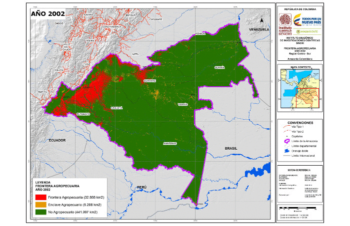
Source: SIAT-AC http://siatac.co/web/guest/productos/frontera-agropecuaria
ZONING AND QUANTIFICATION OF AREAS TO RESTORE IN WATER CIRCLES, SPRINGS AND SOILS WITH SLOPES> 100% IN THE COLOMBIAN AMAZON.
Understanding the state of the protective coverings in water circles and soils with slopes greater than 100%, and monitoring their changes, is necessary to conserve water and soil resources, maintain connectivity and support ecological restoration in the Amazon. However, the country lacks explicit spatial information to monitor these changes. This study carried out zoning and quantification, by means of spatial multicriteria analysis, of surfaces that have changed natural coverings for anthropic ones, in circles and springs and in soils with slopes> 100%; the selection criteria were terrestrial coverage, slope of the terrain, geomorphological landscapes and hydrographic network; and as restrictive criteria, slopes 100% 13,668 ha., in these units the anthropic coverage increased from 930,042 ha., in 2002 to 1,069,570 ha., in 2007 and 1,151,999 ha in 2012; the departments with the largest area transformed into these two protection zones are Caqueta, Meta, Putumayo and Guaviare in the three periods; and the largest increases in the period 2002-2012 were detected in the departments of Meta, Caqueta and Guaviare ...
AUTHORS:
Uriel Gonzalo Murcia García
Julier Fonseca
Fernando Tobon
EFFECT OF THE CONNECTIVITY OF THE AMAZON RIVER ON THE PHYSICS AND CHEMISTRY OF WATERS IN THE FLOOD PLAIN ENVIRONMENTS OF COLOMBIA
This project analyzes the relationship between the physical and chemical variables of aquatic ecosystems, according to the degree of connectivity between the Amazon River and its tributaries. Variables were sampled as depth, temperature, dissolved oxygen, conductivity and pH in twenty lakes, six small tributaries and one sector of the Colombian Amazon River in two hydrological periods (low and rising waters). Through Principal Components Analysis (PCA) and Discriminant Analysis (DA) it was established that the physical and chemical characteristics of water are determined by the type of water, by the physiographic characteristics and by the degree of connectivity with the Amazon River, this system being the computer of the limnological conditions of most of the ecosystems visited. It was determined that white water environments or those with a higher level of connection with the Amazon River recorded the highest values of pH and conductivity. On the other hand, aquatic environments that are further away and therefore have no influence from the Amazon have lower mineralization in general. Regarding the type, the environments of black and intermediate waters reach the lowest values in mineralization and pH, also the majority of the environments present a condition of mesophrophic tría. Finally, an explanatory model is presented regarding the limnological relationships and their temporal effect (hydrological periods) and connectivity (relationship with the Amazon River)...
AUTHORS:
Liliana Palma
Marcela Núñez Avellaneda
Santiago R. Duque
MODELING OF HYDROLOGICAL ECOSYSTEMIC SERVICES AND DINAMICS FOR LAND USE IN THE MOCOA RIVER BASIN
The present article addresses a characterization of the socioeconomic conditions of the municipality of Mocoa, and an exercise of modeling hydrological ecosystem services for the Mocoa river basin. In this sense, an estimation of water supply and sediment retention is presented as prioritized ecosystem services for the exercise in hydrological modeling, starting from different scenarios of climatic variability and climate change. Likewise, an analysis of the changes in erosion control in two areas of strategic importance for the water supply of the municipality of Mocoa is considered, for which the impact on the increase of sediments under loss of forrest coverage conditions is considered. Based on the above, an overview of hydrological ecosystem services for the Mocoa River is established, as a way to understand the distribution of these services and possible trends that may affect the beneficiaries of the water resource. To this end, the different interests for the development of extractive activities in the basin are also considered, which will lead to changes in land use, which translates into impacts on the well-being of the population and future challenges to guarantee the quantity and quality of the water resource ...
AUTHORS:
Miguel Bedoya Paniagua
Elizabeth Riaño Umbarila
Mauro Reyes Bonilla
Carlos Salazar Cardona